
Controlled Parking Zones coming to streets near you! Last chance to comment!
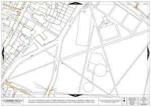
Important! The City Council is now moving forward (1st TRO advertisement) with the introduction of Controlled Parking Zones for Abbeyhill, Leith Walk, Pilrig, Leith and North Leith, which were first proposed and discussed back in 2019. ‘Leith’ covers some (but not all) of the Leith Links area, see map below. And it will definitely also affect other parts of our area that are just on/beyond the boundary, as parking will ‘migrate’ from the controlled zone to the nearest free parking. The boundary is along the edge of the Links, so there will be increased demand for parking on Vanburgh, Hermitage & East Hermitage Place, Gladstone Place and Claremont Park, and other streets nearest these.

NB. This is different from and not to be confused with the proposed CPZ for our area earlier this year (the area inaccurately referred to as ‘West Leith’) which has been paused / postponed until later in 2022. Final plans and consultation of that are still to come, next year.
They are inviting feedback and comments on the final design proposal. These have to be made in writing by 12th November so there is not much time.
To view detailed plans and further information regarding the proposals, please visit the consultation website:
http://pclengagement-hub.co.uk/en-GB/folders/parkingreviewph1
With comments on the proposals or any details of them, please email by 12th November to the team at Edinburgh.Consultation@projectcentre.co.uk
It’s not an easy process!
Click on the project link and then scroll down and click on EDINBURGH AREA N8
https://pclengagement-hub.co.uk/en-GB/projects/leith-northleith
Look on the map and note the number of the area you are interested in. Then scroll down through all the separate ’tile’ maps till you get to that number. Each number has two tile maps, showing the existing parking situation and then the proposed changes.
For example tile 939 will show you Duncan Place, Academy Street, Wellington Place, Johns Place.

Having looked at the numbered tile map, you have to keep referring to the legend map at the top of the page so you know what each colour indicates. For example pink is resident parking, brown is pay and display/resident parking, shared – and so on.
*
The faff of finding the right pages and working out what each colour means is is pretty off-putting. But please do try to have a look and email in your comments, it’s the only chance for the local community to affect the final decisions. This Community Council will TRY to get an online meeting set up so that local residents can ask questions and comment directly, but we don’t know yet if this can be done.
The stated aim of the proposals is, amongst other things, to make it impossible for drivers from out of town to use our area as a ‘Park and Ride’, where they would park and then take the tram into town. That does make sense. But do the specific plans for your street make sense? You know your streets and the behaviour and needs of residents better than the Council or a firm of ‘consultants’.
You can copy your comments to us at the Community Council if you wish, that helps us get a ‘feel’ for the views of local residents. But don’t JUST send to us, you MUST send your comments directly to the Edinburgh.Consultation@projectcentre.co.uk